Dodge Grand Caravan (2020 year). Manual in english - page 21
 

  Index      Manuals     Dodge Grand Caravan (2020 year). Manual in english


Search            copyright infringement  


Content      ..     19      20      21      22     ..


Dodge Grand Caravan (2020 year). Manual in english - page 21


MULTIMEDIA

327

Using The Calculator
From the main menu press Tools > Calculator.

Using The Unit Converter

1. From the main menu press Tools > Unit 

Converter.

2. Press the box with a unit of measurement 

listed.

3. Select a unit of measurement.

4. Press Save.

Two units of measurement are listed.

5. Press a unit of measurement to change.

6. Select a unit of measurement.

7. Press Done.

8. Repeat steps five to six, if necessary.

9. Enter a value.

10. Press Done.

Setting Currency Conversion Rates Manually
You can update the currency conversion rates 

manually so that you are always using the most 

current rates.

1. From the main menu press Tools > Unit 

Converter.

2. Press the box with a currency listed.

3. Select Currency.

4. Press Save.

5. Press a currency box.

6. Select the currency you want to update.

7. Repeat steps three to six to select a 

currency to convert to, if necessary.

8. Press a box under a currency.

9. Enter a new value for the currency.

10. Press Done.

11. Repeat steps eight to nine, if necessary.

Customizing The Navigation System

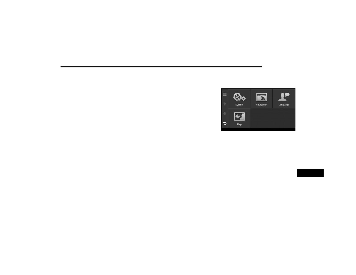
1. From the main menu, press “Settings.”

2. Press a setting category.

3. Press the setting to change it.

System Settings
From the main menu press Settings > System.

GPS Simulator— stops the navigation system 

from receiving a GPS signal, and saves 

battery power.

About— displays the software version 

number, the unit ID number and information 

on several other software features.

9

328

MULTIMEDIA


NOTE:

You need this information when you update the 

system software or purchase additional map 

data.

Restoring The System Settings
From the main menu, press Settings > System 
>  > Restore.

Changing The Map Settings
From the main menu press Settings > Map.

Map Detail — sets the level of detail on the 

map. More detail may result in slower map 

drawing.

Map View — sets the perspective on the Map 

page.

Map Theme — changes the color of the map 

data.

Map Data Layout — changes the amount of 

data visible on the map.

Vehicle — changes the icon to represent your 

position on the map.

Trip Log

Show on Map — displays the path of your 

travels on the map.

Clear Trip Log

Changing The Map Perspective

1. From the main menu press Settings > Map 

> Map View.

2. Select an option:

PressTrack Up to display the map in two 

dimensions (2-D), with your direction of 

travel at the top.

Press North Up to display the map in 2-D 

with North at the top.

Press 3-D to display the map in three 

dimensions.

Route Preferences
From the main menu, press Settings > 

Navigation > Route Preference.
The route calculation is based on road speeds 

and vehicle acceleration data for a given route.

Faster Time — Calculates routes that are 

faster to drive but can be longer in distance.

Shorter Distance — Calculates routes that are 

shorter in distance but can take more time to 

drive.

Prompted — Select the faster time and 

shorter distance for your route.

Avoiding Road Features

1. From the main menu press Settings > 

Navigation > Avoidances.

2. Select the road features to avoid on your 

routes.

3. Press “Save.”

Restoring The Original Navigation Settings
From the main menu press Settings > 
Navigation >  > Restore.

MULTIMEDIA

329

Language Settings
From the main menu press Settings > 

Language.

Voice Personality — sets the language for 

voice prompts.

Keyboard — sets the language for your 

keyboard.

Keyboard Layout — sets the keyboard layout.

Restoring The Original Language Settings

From the main menu press Settings > 
Language >  > Restore.

Restoring All Original Settings
From the main menu, press Settings >  > 

Restore > Yes.

Appendix

About GPS Satellite Signals
The navigation system must acquire satellite 

signals in order to navigate.
When the navigation system has acquired 

satellite signals, the signal strength bars on the 
main menu are full  . When it loses satellite 
signals, the bars are clear  .

For more information about GPS, go to 

www.garmin.com/aboutGPS

.

Updating The Software
To update the navigation system software, you 

must have a USB mass storage device and an 

Internet connection.

1. Go to 

auto-update.garmin.com

.

2. Find your model and select Software 

Updates > Download.

3. Read and accept the terms of the Software 

License Agreement.

4. Follow the instructions on the Web site to 

complete the installation of the software 

update.

Updating The Map Data
To update the navigation system map, you must 

have a USB mass storage device and an 

Internet connection, or visit your local dealer for 

assistance. A map update can be purchased 

once a year.

1. Go to 

auto-update.garmin.com

.

2. Select your vehicle from the drop-down lists.

3. Select Order Map Updates for your unit.

4. Follow the Web site instructions to update 

your map.

CAUTION
Garmin and FCA US LLC are not responsible for 

the accuracy of, or the consequences of using, 

a safety camera database.
Safety camera information is available in some 

locations. Go to 

http://www.garmin.com

 for 

availability. For these locations, the navigation 

system includes the locations of hundreds of 

safety cameras. Your navigation system alerts 

you when you are approaching a safety camera 

and can warn you if you are driving too fast. The 

data is updated at least weekly, so you always 

have access to the most up-to-date information.
You can purchase a new region or extend an 

existing subscription at any time. Each region 

that you purchase has an expiration date.

9

330

MULTIMEDIA


Custom POIs (Points of Interest)

NOTE:

Custom POI files must be named “poi.gpi”. and 

located on the USB storage device in a folder 

named “POI” within a folder named “Garmin” 

(Garmin/POI/).

You can manually load custom Points Of 

Interest (POI) databases, available from various 

companies on the Internet. Some custom POI 

databases contain alert information for points 

such as safety cameras and school zones. The 

navigation system can notify you when you 

approach one of these points. You are 

responsible for ensuring that your use of safety 

camera information is lawful in your area.

CAUTION
Garmin and FCA US LLC are not responsible for 

the consequences of using custom POI 

databases, or for the accuracy of custom POI 

databases.

After downloading your POI database, use the 

Garmin POI Loader to install the POIs onto a 

USB mass storage device. Use the USB mass 

storage device to load the POIs. The POI Loader 

is available at 

garmin.com/products/poiloader

Refer to the POI Loader Help file for more 

information; click Help to open the Help file. The 

file name can only be POI.gpi. No other file 

name or extension should be used.

NOTE:

Each time you load custom POIs to the 

navigation system, any other custom POIs 

already saved in the system will be overwritten.

Finding Custom POIs
You can view a list of the custom POIs loaded in 

your navigation system.

Press Where To? > Extras > Custom POIs.

Deleting Custom POIs

1. Press Tools > My Data > Delete Custom 

POI(s).

2. Press Yes to confirm.

NOTE:

All custom POIs will be deleted from your 

navigation system.

Saving Trip Logs
Trip logs are recorded while you navigate a 

route.

SiriusXM® Travel Link (Radio 430 NAV Only)

Now, in addition to delivering over 130 

channels of the best sports, entertainment, talk 

and 100% commercial-free music, SiriusXM® 

now offers premium infotainment services that 

work in conjunction with compatible navigation 

systems.
To access SiriusXM® Travel Link, push the 

Menu button then press the Travel Link button.

MULTIMEDIA

331

SiriusXM® Travel Link brings a wealth of useful 

information into your vehicle and right to your 

fingertips.

NOTE:

SiriusXM® Travel Link data services 

subscription is separate from your SiriusXM® 

Satellite Radio (audio) subscription.

Weather

View detailed current conditions at your 

current location.

Check extended 12-hour and 5-day fore

-

casts.

Store a favorite location for quick access to 

weather conditions and forecasts.

Ski Info

View ski and snowboarding conditions at ski 

resorts.

Store a favorite location for quick access to 

snow conditions.

Fuel Prices

Check detailed price information for fuel 

stations near your current location.

Sort the list of closest fuel stations by price, 

distance or alphabetically.

Route to selected fuel station.

Store a favorite fuel station for quick access 

to pricing.

Movie Listings

Check which movies are playing at theaters 

near your current location.

Sort the list of theaters by distance or alpha

-

betically.

Show movie titles, start times, ratings, run 

length, and summaries.

Store a favorite theater for quick access to 

schedules.

Sports Scores

View scores and upcoming events for all 

major sports.

Store your favorite teams for quick access to 

the scores and schedules.

9

332

MULTIMEDIA


NOTE:

SiriusXM® Travel Link data services 

subscription is separate from your SiriusXM® 

Satellite Radio (audio) subscription.

SiriusXM® and all related marks and logos are 

trademarks of SiriusXM® Radio Inc. and its 

subsidiaries. SiriusXM® Radio requires a 

subscription, sold separately after trial 

subscription included with vehicle purchase. 

Prices and programming are provided by 

SiriusXM® and are subject to change. 

Subscriptions governed by Terms & Conditions 

available at 

www.sirius.com/serviceterms

SiriusXM® Radio U.S. service only available to 

those at least 18 years of age in the 48 

contiguous United States, D.C., & PR. Visit 

www.sirius.com/TravelLink

 for more 

information on SIRIUS Travel Link.

End-User License Agreement

Software License Agreement
BY USING THE NAVIGATION SYSTEM, YOU 

AGREE TO BE BOUND BY THE TERMS AND 

CONDITIONS OF THE FOLLOWING SOFTWARE 

LICENSE AGREEMENT. PLEASE READ THIS 

AGREEMENT CAREFULLY.
Garmin® Ltd. and its subsidiaries (“Garmin®”) 

grant you a limited license to use the software 

embedded in this device (the “Software”) in 

binary executable form in the normal operation 

of the product. Title, ownership rights, and 

intellectual property rights in and to the 

Software remain in Garmin® and/or its 

third-party providers.
You acknowledge that the Software is the 

property of Garmin® and/or its third-party 

providers and is protected under the United 

States of America copyright laws and interna

-

tional copyright treaties. You further 

acknowledge that the structure, organization, 

and code of the Software, for which source code 

is not provided, are valuable trade secrets of 

Garmin® and/or its third-party providers and 

that the Software in source code form remains 

a valuable trade secret of Garmin® and/or its 

third-party providers. You agree not to 

decompile, disassemble, modify, reverse 

assemble, reverse engineer, or reduce to 

human readable form the Software or any part 

thereof or create any derivative works based on 

the Software. You agree not to export or 

re-export the Software to any country in 

violation of the export control laws of the United 

States of America or the export control laws of 

any other applicable country.
NAVTEQ End-user License Agreement
The software embedded in your Garmin® 

product (the “Software”) is owned by Garmin® 

Ltd. or its subsidiaries (“Garmin®”). The 

third-party map data embedded in or 

accompanying your Garmin® product 

(the “Map Data”) is owned by NAVTEQ North 

America LLC and/or its affiliates (“NAVTEQ”) 

and is licensed to Garmin®. Garmin® also 

licenses information, text, images, graphics, 

photographs, audio, video, images and other 

applications and data from third party data 

providers (“Third Party Content Data”). The Map 

Data and Third Party Content Data are collec

-

tively the “Data”. Both the Software and Data 

are protected under copyright laws and interna

-

tional copyright treaties. The Software and Data 

are licensed, not sold. The Software and Data 

are provided under the following license and 

CAUTION!

Neither SiriusXM® nor FCA US LLC is 

responsible for any errors in accuracies in the 

SiriusXM® data services or its use in 

vehicles.

MULTIMEDIA

333

are subject to the following terms and 

conditions which are agreed to by End User 

(“you” or “your”), on the one hand, and 

Garmin® and its licensors (including their 

licensors and suppliers) and affiliated 

companies on the other hand.
IMPORTANT: CAREFULLY READ THIS LICENSE 

BEFORE USING THIS PRODUCT. INSTALLING, 

COPYING, OR OTHERWISE USING THIS 

PRODUCT INDICATES YOUR ACKNOWL

-

EDGMENT THAT YOU HAVE READ THIS LICENSE 

AND AGREE TO ITS TERMS. IF YOU DO NOT 

AGREE, RETURN THE COMPLETE PRODUCT 

WITHIN 7 DAYS OF THE DATE YOU ACQUIRED IT 

(IF PURCHASED NEW) FOR A FULL REFUND TO 

THE DEALER FROM WHICH YOU PURCHASED 

THIS PRODUCT.
License Terms And Conditions
Garmin® (“we” or “us”) provides you with 

storage media containing the computer 

Software (the “Software”) and the embedded or 

accompanying Data, including any “online” or 

electronic documentation and printed materials 

(together called the “Product” for purposes of 

this License Agreement), and grants you a 

limited, non-exclusive license to use the 

Product in accordance with the terms of this 

Agreement. You agree to use this Data together 

with the Garmin® product for solely personal, or 

if applicable, for use in your business’ internal 

operations, and not for service bureau, 

time-sharing, resale or other similar purposes. 

Accordingly, but subject to the restrictions set 

forth in the following paragraphs, you may copy 

this Data only as necessary for your use to (i) 

view it, and (ii) save it, provided that you do not 

remove any copyright notices that appear and 

do not modify the Software or Data in any way. 

You agree not to otherwise reproduce, copy, 

modify, decompile, disassemble, reverse 

engineer or create derivative works of any 

portion of the Product, and may not transfer or 

distribute it in any form, for any purpose, except 

to the extent permitted by mandatory laws. 

Garmin® also reserves the right to discontinue 

offering any Data supplied by any third party 

supplier if such supplier ceases to supply such 

content or Garmin’s® contract with such 

supplier terminates for any reason.
Restrictions. Except where you have been 

specifically licensed to do so by Garmin®, and 

without limiting the preceding paragraph, you 

may not use this Data with any products, 

systems, or applications installed or otherwise 

connected to or in communication with 

vehicles, and which are capable of dispatch, 

fleet management or similar applications where 

the Data is used by a central control center in 

dispatching a fleet of vehicles. In addition, you 

are prohibited from renting or leasing the Data 

or the Garmin® products containing the Data to 

any other person or third party. Only those 

rental car companies that are specifically 

authorized by Garmin® in writing to rent 

Garmin® products containing the Data to their 

rental customers are permitted to rent out such 

products.
nüMaps Lifetime. If you purchase a nüMaps 

Lifetime subscription (sold separately) or if your 

Garmin® product comes bundled with a 

nüMaps Lifetime subscription, you will receive 

up to four (4) Map Data updates per year, when 

and as such updates are made available on 

Garmin’s® website, for one (1) compatible 

Garmin® product until your product’s useful life 

expires or Garmin® no longer receives Map 

Data from NAVTEQ, whichever is shorter. A 

product’s “useful life” means the period during 

which the product (a) has sufficient memory 

capacity and other required technical 

capabilities to utilize current map data and (b) is 

capable of operating as intended without major 

repairs. A product will be deemed to be out of 

service and its useful life to be ended if no 

9

334

MULTIMEDIA


updates have been downloaded for such 

product for a period of 24 months or more. 

Unless otherwise stated, the updates you 

receive under the subscription will be updates 

to the same geographic Map Data originally 

included with your Garmin® product when 

originally purchased. In some instances, your 

Garmin® product might not have sufficient 

memory remaining for you to load an update to 

the same Map Data originally included with your 

Garmin® product, in which case you will need to 

either (a) select reduced Map Data coverage for 

your updates, or (b) purchase separately a 

microSD card or a SD card (if and as applicable 

to your Garmin® product) and load all or a 

portion of the Map Data coverage for your 

updates to the card and insert the card into the 

microSD card or SD card slot contained in your 

Garmin® product. If neither of the measures in 

(a) or (b) can be used to address your product’s 

lack of sufficient remaining memory, then 

Garmin® may conclude that the “useful life” of 

your product has expired. Garmin® may 

terminate your nüMaps Lifetime subscription at 

any time if you violate any of the terms of this 

Agreement or your subscription. Your nüMaps 

Lifetime subscription may not be transferred to 

another person or another Garmin® product.

No Warranty. This Product (including the Data) 

is provided to you “as is,” and you agree to use 

it at your own risk. Garmin® and its licensors 

(and their licensors and suppliers) make no 

guarantees, representations or warranties of 

any kind, express or implied, arising by law or 

otherwise, including but not limited to, content, 

quality, accuracy, completeness, effectiveness, 

reliability, merchantability, fitness for a 

particular purpose, usefulness, use or results to 

be obtained from the Product, or that the Data 

or server will be uninterrupted or error-free.
Disclaimer of Warranty. GARMIN AND ITS 

LICENSORS (INCLUDING THEIR LICENSORS 

AND SUPPLIERS) DISCLAIM ANY WARRANTIES, 

EXPRESS OR IMPLIED, OF QUALITY, 

PERFORMANCE, MERCHANTABILITY, FITNESS 

FOR A PARTICULAR PURPOSE OR 

NONINFRINGEMENT. NO ORAL OR WRITTEN 

ADVICE OR INFORMATION PROVIDED BY 

GARMIN OR ITS SUPPLIERS AND LICENSORS 

SHALL CREATE A WARRANTY, AND YOU ARE 

NOT ENTITLED TO RELY ON ANY SUCH ADVICE 

OR INFORMATION. THIS DISCLAIMER OF 

WARRANTIES IS AN ESSENTIAL CONDITION OF 

THIS AGREEMENT. Some States, Territories and 

Countries do not allow certain warranty 

exclusions, so to that extent the above 

exclusion may not apply to you.
Disclaimer of liability. GARMIN AND ITS 

LICENSORS (INCLUDING THEIR LICENSORS 

AND SUPPLIERS) SHALL NOT BE LIABLE TO 

YOU: IN RESPECT OF ANY CLAIM, DEMAND OR 

ACTION, IRRESPECTIVE OF THE NATURE OF THE 

CAUSE OF THE CLAIM, DEMAND OR ACTION 

ALLEGING ANY LOSS, INJURY OR DAMAGES, 

DIRECT OR INDIRECT, WHICH MAY RESULT 

FROM THE USE OR POSSESSION OF THE 

INFORMATION; OR FOR ANY LOSS OF PROFIT, 

REVENUE, CONTRACTS OR SAVINGS, OR ANY 

OTHER DIRECT, INDIRECT, INCIDENTAL, 

SPECIAL OR CONSEQUENTIAL DAMAGES 

ARISING OUT OF YOUR USE OF OR INABILITY TO 

USE THIS INFORMATION, ANY DEFECT IN THE 

DATA OR INFORMATION, OR THE BREACH OF 

THESE TERMS OR CONDITIONS, WHETHER IN 

AN ACTION IN CONTRACT OR TORT OR BASED 

ON A WARRANTY, EVEN IF GARMIN OR ITS 

LICENSORS HAVE BEEN ADVISED OF THE 

POSSIBILITY OF SUCH DAMAGES. GARMIN’S 

AND ITS LICENSORS’ TOTAL AGGREGATE 

LIABILITY WITH RESPECT TO ITS OBLIGATIONS 

UNDER THIS AGREEMENT OR OTHERWISE 

WITH RESPECT TO THE GARMIN PRODUCT OR 

MULTIMEDIA

335

THE DATA SHALL NOT EXCEED $1.00. Some 

States, Territories and Countries do not allow 

certain liability exclusions or damages 

limitations, so to that extent the above may not 

apply to you.
Disclaimer of Endorsement. Reference to any 

products, services, processes, hypertext links to 

third parties or other Data by trade name, 

trademark, manufacturer, supplier or otherwise 

does not necessarily constitute or imply its 

endorsement, sponsorship or recommendation 

by Garmin® or its licensor. Product and service 

information are the sole responsibility of each 

individual vendor. The NAVTEQ name and logo, 

the NAVTEQ and NAVTEQ ON BOARD 

trademarks and logos, and other trademarks 

and trade names owned by NAVTEQ North 

America LLC may not be used in any 

commercial manner without the prior written 

consent of NAVTEQ.
Export Control. You agree not to export from 

anywhere any part of the Data provided to you 

or any direct product thereof except in 

compliance with, and with all licenses and 

approvals required under, applicable export 

laws, rules and regulations.

Indemnity. You agree to indemnify, defend and 

hold Garmin® and its licensors (including their 

respective licensors, suppliers, assignees, 

subsidiaries, affiliated companies, and the 

respective officers, directors, employees, 

shareholders, agents and representatives of 

each of them) free and harmless from and 

against any liability, loss, injury (including 

injuries resulting in death), demand, action, 

cost, expense, or claim of any kind or character, 

including but not limited to attorney’s fees, 

arising out of or in connection with any use or 

possession by you of the Product (including the 

Data).
Canadian Map Data. The Map Data for Canada 

may include or reflect data of licensors, 

including Her Majesty and Canada Post. Such 

data is licensed on an “as is” basis. The 

licensors, including Her Majesty and Canada 

Post, make no guarantees, representations or 

warranties respecting such data, either express 

or implied, arising by law or otherwise, including 

but not limited to, effectiveness, completeness, 

accuracy or fitness for a particular purpose. The 

licensors, including Her Majesty and Canada 

Post, shall not be liable in respect of any claim, 

demand or action, irrespective of the nature of 

the cause of the claim, demand or action 

alleging any loss, injury or damages, direct or 

indirect, which may result from the use or 

possession of the data or the Map Data. The 

licensors, including Her Majesty and Canada 

Post, shall not be liable in any way for loss of 

revenues or contracts, or any other 

consequential loss of any kind resulting from 

any defect in the data or the Map Data. You 

shall indemnify and save harmless the 

licensors, including Her Majesty the Queen, the 

Minister of Natural Resources of Canada and 

Canada Post, and their officers, employees and 

agents from and against any claim, demand or 

action, irrespective of the nature of the cause of 

the claim, demand or action, alleging loss, 

costs, expenses, damages or injuries (including 

injuries resulting in death) arising out of the use 

or possession of the data or the Map Data. The 

terms contained in this Section are in addition 

to all of the rights and obligations of the parties 

under the Agreement. To the extent that any of 

the provisions of this Section are inconsistent 

with, or conflict with, any other provisions of the 

Agreement, the provisions of this Section shall 

prevail.

9

336

MULTIMEDIA


United States Map Data. NAVTEQ holds a 

non-exclusive license from the United States 

Postal Service to publish and sell 

ZIP+4 information. ©United States Postal 

Service 2010. Prices are not established, 

controlled or approved by the United States 

Postal Service. The following trademarks and 

registrations are owned by the USPS: United 

States Postal Service, USPS, and ZIP+4.
Canadian Map Data. Map Data for Canada 

includes information taken with permission 

from Canadian authorities, including © Her 

Majesty, © Queen's Printer for Ontario, © 

Canada Post, GeoBase, © Department of 

Natural Resources Canada. All rights reserved.
Australian Map Data. Map Data for Australia is 

based on data NAVTEQ has licensed from PSMA 

Australia Limited (www.psma.com.au). In 

addition, the Product incorporates data which is 

Limited, Intelematics Australia Pty Ltd, Sentinel 

Content Pty Limited and Continental Pty Ltd. If 

your Product uses RDS-TMC Codes contained in 

the Map Data, the traffic location codes are © 

2019 Telstra Corporation Limited and its 

licensors.

Term. This Agreement is effective until such 

time as (i) if applicable, your subscription term 

is either terminated (by you or by Garmin®) or 

expires, or (ii) Garmin® terminates this 

Agreement for any reason, including, but not 

limited to, if Garmin® finds that you have 

violated any of the terms of this Agreement. In 

addition, this Agreement shall terminate 

immediately upon the termination of an 

agreement between Garmin® and any third 

party from whom Garmin® licenses the Data.
Entire Agreement. These terms and conditions 

constitute the entire agreement between 

Garmin (and its licensors, including their 

licensors and suppliers) and you pertaining to 

the subject matter hereof, and supersedes in 

their entirety any and all written or oral 

agreements previously existing between us with 

respect to such subject matter.
Governing Law.
(a) For European Union NAVTEQ Data
The above terms and conditions shall be 

governed by the laws of the Netherlands, 

without giving effect to (i) its conflict of laws 

provisions, or (ii) the United Nations Convention 

for Contracts for the International Sale of 

Goods, which is explicitly excluded. You agree to 

submit to the jurisdiction of the Netherlands for 

any and all disputes, claims and actions arising 

from or in connection with the NAVTEQ Data 

provided to you hereunder.
(b) For North American NAVTEQ Data and other 

non-European Union NAVTEQ Data
The above terms and conditions shall be 

governed by the laws of Illinois, without giving 

effect to (i) its conflict of laws provisions, or (ii) 

the United Nations Convention for Contracts for 

the International Sale of Goods, which is 

explicitly excluded. You agree to submit to the 

jurisdiction of Illinois for any and all disputes, 

claims and actions arising from or in connection 

with the NAVTEQ Data provided to you 

hereunder.
(c) For disputes, claims and actions not related 

to the NAVTEQ Data
The above terms and conditions shall be 

governed by the laws of Kansas, without giving 

effect to (i) its conflict of laws provisions, or (ii) 

the United Nations Convention for Contracts for 

the International Sale of Goods, which is 

explicitly excluded. You agree to submit to the 

jurisdiction of Kansas for any and all disputes, 

claims and actions arising from or in connection 

with the Data provided to you hereunder.

MULTIMEDIA

337

Government End Users. If End User is an 

agency, department, or other entity of the 

United States Government, or funded in whole 

or in part by the U.S. Government, then use, 

duplication, reproduction, release, modifi

-

cation, disclosure or transfer of the Product and 

accompanying documentation is subject to 

restrictions as set forth in DFARS 

252.227-7014(a)(1) (JUN 1995) (DOD 

commercial computer software definition), 

DFARS 27.7202-1 (DOD policy on commercial 

computer software), FAR 52.227-19 (JUN 

1987) (commercial computer software clause 

for civilian agencies), DFARS 252.227-7015 

(NOV 1995) (DOD technical data – commercial 

items clause); FAR 52.227-14 Alternates I, II, 

and III (JUN 1987) (civilian agency technical 

data and noncommercial computer software 

clause); and/or FAR 12.211 and FAR 12.212 

(commercial item acquisitions), as applicable. 

In case of conflict between any of the FAR and 

DFARS provisions listed herein and this 

License, the construction that provides greater 

limitations on the Government’s rights shall 

control. The contractor/manufacturer is 

Garmin® International, Inc., 1200 East 151st 

Street, Olathe, KS 66062, USA and NAVTEQ 

North America LLC, 425 West Randolph Street, 

Chicago, Illinois 60606 USA.
Garmin® is a trademark of Garmin® Ltd. or its 

subsidiaries, registered in the USA and other 

countries. These trademarks may not be used 

without the express permission of Garmin®.
NAVTEQ is a trademark in the U.S. and other 

countries. All other company names and 

trademarks mentioned or referenced in this 

documentation are the properties of their 

respective owners. All rights reserved.
DMTI Spatial, Inc. End User License Agreement
The software embedded in your Garmin® 

product is owned by Garmin® Ltd. or its subsid

-

iaries (“Garmin®”). The third-party postal code 

data (the “Licensed Product”) embedded in or 

accompanying your Garmin® product is owned 

by DMTI Spatial, Inc. and is licensed to 

Garmin®. Both the software and Licensed 

Product are protected under copyright laws and 

international copyright treaties.
THIS is a legal Agreement between you, the end 

user, and DMTI Spatial, Inc. BY LOADING THE 

PRODUCT(S) WITH THIS AGREEMENT YOU ARE 

AGREEING TO BE BOUND BY THE TERMS OF 

THIS AGREEMENT. IF YOU DO NOT AGREE TO 

THE TERMS OF THIS AGREEMENT, PROMPTLY 

(within 7 days of purchase) RETURN THE 

PRODUCTS AND ANY ACCOMPANYING ITEMS 

(including written materials) TO Garmin® 

INTERNATIONAL, INC. CUSTOMER SERVICE, 

1200 EAST 151ST STREET, OLATHE, KANSAS 

66062, FOR A REFUND.
DMTI Spatial hereby grants to you a 

non-exclusive, non-transferable license to use 

the data contained on the media in this 

package (the “Licensed Product”) solely for 

personal non-commercial use or internal use in 

your business, on a single computer, Pocket PC, 

or Palm device in conjunction with Garmin® 

software, and with compatible Garmin® 

products that you personally own. Your use of 

the data is subject to the following terms and 

conditions:
You acknowledge that the Licensed Product(s) 

belong to DMTI Spatial and its third party 

supplier, and that the Licensed Product(s) are 

copyrighted. Unauthorized copying of the 

Licensed Product(s), is expressly forbidden and 

you may be held legally responsible for 

copyright infringement which is caused or 

encouraged by your failure to abide by the terms 

of this agreement. You may make one archival 

copy of the Licensed Product(s), solely for your 

own use, subject to the following restrictions: 

9

338

MULTIMEDIA


(1) The archival copy must be treated in the 

same way as the original copy; (2) No copy may 

be used while any other copy is in use. If you 

make an archival copy of the Licensed 

Product(s), you must include on it the copyright 

notice that is on the original media.
You may not reproduce, sell, rent, lease, loan, 

distribute or sublicense the Licensed Product(s) 

or otherwise transfer the Licensed Product(s) to 

any third party, use the Licensed Product for 

commercial purposes except for internal use in 

your business, decompile, disassemble, 

reverse-engineer the Licensed Product(s), or 

use the Licensed Product to create any derived 

product for any of these prohibited purposes. 

You may not place the Licensed Product(s) on 

the Internet without a prior written agreement 

with DMTI Spatial.
In no event shall DMTI Spatial or its third party 

supplier(s) be liable to you or your organization 

for any indirect damages including any lost 

profits, lost savings, interruption of business, 

loss of business opportunities or other 

incidental or consequential damages, arising 

out of your possession, use of, or inability to use 

the Licensed Product(s), even if DMTI Spatial, 

its third party supplier(s), or any authorized 

dealer, has been advised of the possibility of the 

damages, or for any claim by any other party. In 

no event shall DMTI Spatial have any liability for 

damage in excess of the license fee paid for the 

Licensed Product(s).
You shall indemnify and hold DMTI Spatial, its 

third party supplier(s) and their officers, 

employees and agents, harmless from and 

against any claim, demand or action, 

irrespective of the nature of the claim, demand 

or action, alleging loss, costs, damages, 

expenses, or injury (including injury from death) 

resulting from your authorized or unauthorized, 

use, possession, modification, or alteration of 

the Licensed Product(s).
THE LICENSED PRODUCT(S) AND THE 

ASSOCIATED WRITTEN MATERIALS IN 

CONNECTION THEREWITH ARE PROVIDED “AS 

IS” WITHOUT WARRANTY OF ANY KIND, EITHER 

EXPRESSED OR IMPLIED, ARISING BY LAW OR 

OTHERWISE, INCLUDING BUT NOT LIMITED TO 

WARRANTIES OF EFFECTIVENESS, 

COMPLETENESS, ACCURACY, MERCHANT

-

ABILITY OR FITNESS FOR A PARTICULAR 

PURPOSE. THE ENTIRE RISK AS TO THE 

QUALITY AND PERFORMANCE OF THE 

LICENSED PRODUCT(S) IS WITH YOU, THE END 

USER. NO ORAL OR WRITTEN ADVICE GIVEN BY 

DMTI SPATIAL OR ITS DEALERS, DISTRIBUTORS, 

AGENTS OR EMPLOYEES CREATES A 

WARRANTY OR IN NAY WAY INCREASES DMTI 

SPATIAL’S LIABILITY AND YOU MAY NOT RELY 

ON ANY SUCH INFORMATION OR ADVICE.
No statement or recommendation made or 

assistance given by DMTI Spatial or by its 

representatives or employees shall constitute a 

waiver by DMTI Spatial or any of the provisions 

herein. Nor does or will DMTI Spatial warrant 

any services it may provide in connection with 

the use of the Licensed product(s), to include 

any assistance, training, or other consultation 

with you.
This license is effective until terminated. This 

license will terminate automatically without 

notice from DMTI Spatial if you fail to comply 

with any provision of this License Agreement. 

Upon termination, you shall destroy or return 

the Licensed Product(s) including any written 

materials and all copies of the Licensed 

Product(s) and any written materials in 

connection therewith have been destroyed or 

returned to DMTI Spatial.
This Agreement shall be governed by the laws of 

licensed from third parties).

MULTIMEDIA

339

DMTI Spatial is an authorized user and 

distributor of selected Statistics Canada 

Computer files under Licensing Agreement 

RIGHT OF CANADA, as represented by the 

Minister of Industry, Statistics Canada 1996.
Digital Topographic Data produced under 

license from Her Majesty the Queen in Right of 

Canada, with permission of Natural Resources 

Canada.
Governing Law. The above terms and conditions 

shall be governed by the laws of the State of 

Illinois, without giving effect to (i) its conflict of 

laws provisions, or (ii) the United Nations 

Convention for Contracts for the International 

Sale of Goods, which is explicitly excluded. You 

agree to submit to the jurisdiction of the State of 

Illinois for any and all disputes, claims and 

actions arising from or in connection with the 

Traffic Data provided to you hereunder.

Government End Users. If the Traffic Data is 

being acquired by or on behalf of the United 

States government or any other entity seeking 

or applying rights similar to those customarily 

claimed by the United States government, this 

Data is a “commercial item” as that term is 

defined at 48 C.F.R. (“FAR”) 2.101, is licensed 

in accordance with this Agreement, and the 

Traffic Data delivered or otherwise furnished 

shall be marked and embedded as appropriate 

with the following “Notice of Use,” and shall be 

treated in accordance with such Notice:
Notice of Use
Contractor (Manufacturer/ Supplier) Name: 

NAVTEQ
Contractor (Manufacturer/supplier) Address: 

425 West Randolph Street, Chicago, Illinois 

60606.
This Data is a commercial item as defined in 

FAR 2.101 and is subject to the NAVTEQ Traffic 

End User License Agreement under which this 

rights reserved.

If the Contracting Officer, federal government 

agency, or any federal official refuses to use the 

legend provided herein, the Contracting Officer, 

federal government agency, or any federal 

official must notify NAVTEQ prior to seeking 

additional or alternative rights in the Traffic 

Data.
NAVTEQ and Traffic.com are trademarks in the 

U.S. and other countries. © 2019 NAVTEQ; © 

2019 Traffic.com. All rights reserved.
HD Radio™ Technology manufactured under 

license from iBiquity Digital Corporation. U.S. 

and Foreign Patents. HD Radio™ and the HD, 

HD Radio™, and "Arc" logos are proprietary 

trademarks of iBiquity Digital Corp.
Garmin® is a trademark of Garmin® Ltd. or its 

subsidiaries, registered in the USA and other 

countries. This trademark may not be used 

without the express permission of Garmin®. All 

other company names and trademarks 

mentioned or referenced in this documentation 

are the properties of their respective owners. All 

rights reserved.

9

340

MULTIMEDIA


STEERING WHEEL AUDIO CONTROLS — IF 

EQUIPPED   

Remote Sound System Controls (Back View Of Steering 

Wheel)

The remote sound system controls are located 

on the rear surface of the steering wheel, at the 

three and nine o'clock positions.
The right-hand rocker switch has a push-button 

in the center, and controls the volume and 

mode of the sound system. Pushing the top of 

the rocker switch will increase the volume. 

Pushing the bottom of the rocker switch will 

decrease the volume. Pushing the center 

button changes the operation of the radio from 

AM to FM, or to CD mode.

The left-hand rocker switch has a push-button in 

the center. The function of the left-hand switch 

is different, depending on which mode you are 

in.
The following describes the left-hand rocker 

switch operation in each mode.

Radio Operation

Pushing the top of the switch will Seek Up for 

the next listenable station, and pushing the 

bottom of the switch will Seek Down for the next 

listenable station.
The button located in the center of the left-hand 

switch will tune to the next preset station that 

you have programmed in the radio preset 

push-button.

CD Player

Pushing the top of the switch once will go to the 

next track on the CD. Pushing the bottom of the 

switch once will go to the beginning of the 

current track, or to the beginning of the previous 

track if it is within one second after the current 

track begins to play.
If you push the switch up or down twice it plays 

the second track; three times, it will play the 

third, etc.

The button in the center of the left-hand switch 

has no function in this mode.

USB/MP3 CONTROL — IF EQUIPPED    

This feature allows a external USB device to be 

plugged into the USB port, located in the glove 

compartment. If equipped, there may also be 

two USB ports located on the lower trim piece 

right behind the driver’s sliding door that are for 

charging devices only.
iPod® control supports Mini, 4G, Photo, iPod® 

nano, 5G iPod® and iPhone® devices. Some 

iPod® software versions may not fully support 

the iPod® control features. Please visit 

Apple’s® website for software updates.

NOTE:

Connecting a consumer electronic audio device 

to the AUX port located in the radio faceplate, 

plays media, but does not use the MP3 control 

feature to control the connected device.

MULTIMEDIA

341

Connecting The External USB Device

Use the connection cable to connect a external 

USB device to the vehicle's USB connector port 

which is located in the glove compartment. 

USB Port

NOTE:

The glove compartment will have a position 

where the consumer electronic audio device 

cable can be routed through without damaging 

the cable when closing the lid. This allows 

routing of the cable without damaging it while 

closing the lid. If a cut out is not available in the 

glove compartment, route the cable away from 

the lid latch and in a place that will allow the lid 

to close without damaging the cable.

Once the audio device is connected and 

synchronized to the vehicle's USB/MP3 control 

system (External USB device may take a few 

minutes to connect), the audio device starts 

charging and is ready for use by pushing radio 

buttons.

NOTE:

If the audio device battery is completely 

discharged, it may not communicate with the 

USB/MP3 control system until a minimum 

charge is attained. Leaving the audio device 

connected to the USB/MP3 control system may 

charge it to the required level.

Using This Feature

By using an external USB device to connect to 

the USB port: 

The audio device can be played on the 

vehicle’s sound system, providing metadata 

(artist, track title, album, etc.) information on 

the radio display.

The audio device can be controlled using the 

radio buttons to Play, Browse, and List the 

audio device’s contents.

The audio device battery charges when 

plugged into the USB connector (if supported 

by the specific audio device).

Controlling The External USB Device Using 

Radio Buttons

To enter the AUX/USB/MP3 control mode and 

access a connected audio device, either push 

the Aux button on the radio faceplate or push 

the VR button and say "USB" or "Switch to USB." 

Once in the AUX/USB/MP3 control mode, audio 

tracks (if available from audio device) start 

playing over the vehicle's audio system.

Play Mode

When switched to AUX/USB/MP3 control mode, 

the external USB device automatically starts 

Play mode. In Play mode, the following buttons 

on the radio faceplate may be used to control 

the external USB device and display data: 

Use the TUNE control knob to select the next 

or previous track. 

Turning it clockwise (forward) by one 

click, while playing a track, skips to the 

next track or push the Voice Recognition 

(VR) button and say "Next Track".

9

342

MULTIMEDIA


Turning it counterclockwise (backward) 

by one click will jump to the previous 

track in the list or push the VR button and 

say "Previous Track".

Jump backward in the current track by 

pushing and holding the << RW button. 

Holding the << RW button long enough will 

jump to the beginning of the current track.

Jump forward in the current track by pushing 

and holding the FF >> button.

A single push backward << RW or forward FF 

>> will jump backward or forward respec

-

tively, for five seconds.

Use the << SEEK and SEEK >> buttons to 

jump to the previous or next track. Pushing 

the SEEK >> button during play mode will 

jump to the next track in the list, or push the 

VR button and say "Next or Previous Track."

While a track is playing, push the INFO button 

to see the associated metadata (artist, track 

title, album, etc.) for that track. Pushing the 

INFO button again jumps to the next screen 

of data for that track. Once all screens have 

been viewed, the last INFO button push will 

go back to the play mode screen on the radio.

Pushing the Repeat button will change the 

audio device mode to repeat the current 

playing track or push the VR button and say 

"Repeat On" or "Repeat Off".

Push the Scan button to use AUX/USB/MP3 

device scan mode, which will play the first 10 

seconds of each track in the current list and 

then forward to the next song. To stop Scan 

mode and start playing the desired track, 

when it is playing the track, push the Scan 

button again. During Scan mode, pushing the 

<< SEEK and SEEK >> buttons will select the 

previous and next tracks.

RND button: Pushing this button toggles 

between Shuffle ON and Shuffle OFF modes 

for the external USB device, or push the VR 

button and say "Shuffle On" or "Shuffle Off." If 

the RND icon is showing on the radio display, 

then the shuffle mode is On.

List Or Browse Mode

During Play mode, pushing any of the buttons 

described below will bring up List mode. List 

mode enables scrolling through the list of 

menus and tracks on the audio device.

Tune control knob: The Tune control knob 

functions in a similar manner as the scroll 

wheel on the audio device or external USB 

device.

Turning it clockwise (forward) and counter

-

clockwise (backward) scrolls through the 

lists, displaying the track detail on the radio 

display. Once the track to be played is high

-

lighted on the radio display, push the Tune 

control knob to select and start playing the 

track. Turning the TUNE control knob fast will 

scroll through the list faster. During fast 

scroll, a slight delay in updating the informa

-

tion on the radio display may be noticeable.

In List mode, the radio Preset buttons are used 

as shortcuts to the following lists on the 

external USB device:

Preset 1 – Playlists

Preset 2 – Artists

Preset 3 – Albums

Preset 4 – Genres

Preset 5 – Audiobooks

Preset 6 – Podcasts


Content      ..     19      20      21      22     ..