Citroen SpaceTourer (2016 year). Instruction - part 23
 

  Index      Citroen     Citroen SpaceTourer - instruction 2016 year in english


Search            


Content   ..  21  22  23  24   ..


Citroen SpaceTourer (2016 year). Instruction - part 23


.

351

1

1

1

1

17

18

8

11

9

12

10

13

16

14

15

Audio and Telematics

Spacetourer-VP_en_Chap10b_NAC-1_ed01-2016

Level 1

Level 2

Level 3

Comments

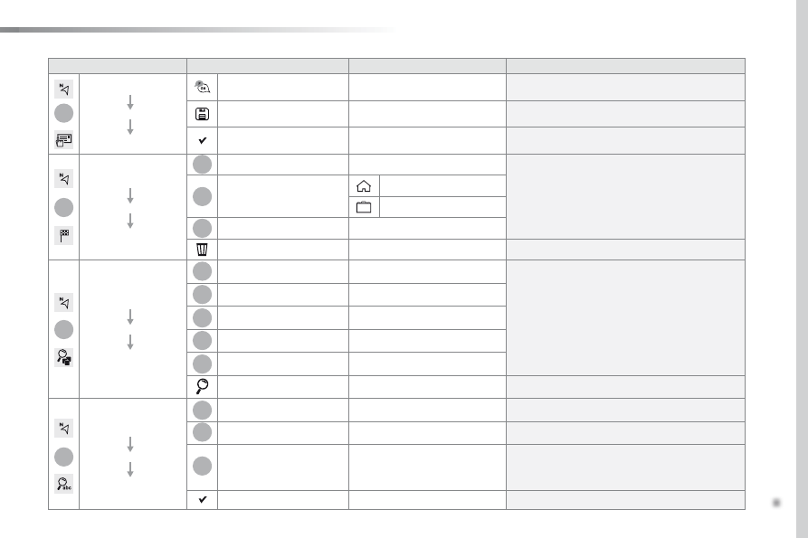
Navigation

Secondary page

Enter address

Select the country.

Save the current address.

Confirm

Confirm the current address.

Navigation

Secondary page

My destinations

Recent

Display the lists of destinations and start 
navigation.

Preferred

My home

My work

Contact

Delete one or more destinations.

Navigation

Secondary page

Points of interest

Travel

List of categories available.
After selection of category, select the point of 
interest.

Active life

Commercial

Public

Geographic

Search

Search for a point of interest.

Navigation

Secondary page

Search

Point of interest

Enter a point of interest.

Address

Enter the address of a point of interest.

Local

 / Connected

Enter settings for the POI search mode in a 
local or connected database depending on the 
services subscribed to.

Confirm

Confirm the entry.

352

1

19

21

20

22 23 24 25

Audio and Telematics

Spacetourer-VP_en_Chap10b_NAC-1_ed01-2016

Level 1

Level 2

Level 3

Navigation menu

Guidance criteria

Route and waypoints

Add waypoint

Settings

Route and waypoints

Settings

.

353

1

1

1

19

21

20

23

22

24

25

Audio and Telematics

Spacetourer-VP_en_Chap10b_NAC-1_ed01-2016

Level 1

Level 2

Level 3

Comments

Navigation

Secondary page

Guidance  

criteria

Fast

Select the guidance criteria (motorways, tolls and 
how traffic is taken into account).

Short

Compromise

Ecological

See on map

Display the route selected using the criteria.

Confirm

Save your selections.

Navigation

Secondary page

Routes / waypoints

Waypoints

Display the waypoints saved.

Route

Display details of the route.

Add waypoint

Add a waypoint

Add a waypoint from a list offered.

Preview

Display the map.

Finish

Press to calculate the route.

Delete one or more waypoints.

Move a waypoint in the list.

Navigation

Secondary page

Settings

Aspects

Enter choices and select the volume for the voice 
and stating the names of streets.

Options

Alerts

Vocal

Mapping

Confirm

Save the selections adopted.

354

1

1

8

Audio and Telematics

Spacetourer-VP_en_Chap10b_NAC-1_ed01-2016

Choosing a new destination

Select "Enter address

".

Select "See on map" to select the 
"Guidance criteria

".

Select the "Country

".

Press "Confirm" to select the 
"Guidance criteria

".

Press "Confirm

" to start navigation.

Press "Confirm

" to start navigation.

And / Or

Press Navigation to display the 
primary page.

Press the "MENU

" button to go to the 

secondary page.

Towards a new destination

Towards a recent destination

Select "My destinations

".

Press Navigation to display the 
primary page.

Press the "MENU

" button to go to the 

secondary page.

Enter the "City", the "Street" and the 
"Number

" and confirm by pressing 

on the suggestions displayed.

Select the "Recent

" tab.

Select the address chosen in the list to display 
the "Guidance criteria

".

To use the navigation system, it is 
necessary to enter the "City", the 
"Street" and the "Number

" using the 

virtual keypad, or to take them from the 
list of "Contacts" or from the "History
of addresses.

Without confirmation of the street 
number, you will be guided to one end 
of the street.

Select "Position" to see the point of 
arrival geographically.

.

355

1

10

1

1

9

Audio and Telematics

Spacetourer-VP_en_Chap10b_NAC-1_ed01-2016

Or

Towards a contact

Select "My destinations

".

Select the "Contact

" tab.

Press Navigation to display the 
primary page.

Press the "MENU

" button to go to the 

secondary page.

Select a contact in the list offered to start 
navigation.

Press "Confirm" to start calculation 
of the route.

Towards points of interest (POI)

Points of Interest (POI) are listed in different 
categories.

Press Navigation to display the 
primary page.

Press the "MENU

" button to go to the 

secondary page.

Select "Points of interest

".

Select "Search" to enter the name 
and address of a POI.

Select the "Travel", or "Leisure
or "Commercial" or "Public" or 
"Geographic

" tab.

Or

Or

Towards "My home" or 
"My work"

Select "My destinations

".

Press Navigation to display the 
primary page.

Press the "MENU

" button to go to the 

secondary page.

Select the "Preferred

" tab.

Select "My home

".

Select "My work

".

Select a previously saved favourite destination.

356

Audio and Telematics

Spacetourer-VP_en_Chap10b_NAC-1_ed01-2016

Towards GPS coordinates

Towards a point on the map

Press Navigation to display the 
primary page.

Press Navigation to display the 
primary page.

Explore the map by sliding a finger on the 
screen.

Explore the map by sliding a finger on the 
screen.

Tap the screen to place a marker and 
display the sub-menu.

Or

Or

OR

And

Select the destination by pressing on the map.

Press this button to start navigation.

Press this button to start navigation.

Press this button to display the world 
map.
Using the grid, select by zoom the 
desired country or region.

Press this button to save the address 
displayed

Press this button to save the address 
displayed.

Press this button to enter the GPS 
coordinates.

Press this button to enter the value 
for "Latitude

" using the virtual 

keypad.

Press this button to enter the value 
for "Longitude

" using the virtual 

keypad.

A marker is displayed in the middle of 
the screen, with the "Latitude" and 
"Longitude

" coordinates.

A long press on a point opens a list of 
POIs nearby.

.

357

Audio and Telematics

Spacetourer-VP_en_Chap10b_NAC-1_ed01-2016

TMC (Traffic Message 
Channel)

TMC (Traffic Message Channel) is a 
European standard on the broadcasting 
of traffic information via the RDS 
system on FM radio, transmitting traffic 
information in real time.
The TMC information is then displayed 
on a GPS Navigation system map and 
taken into account straight away during 
navigation, so as to avoid accidents, 
traffic jams and closed roads.

The display of danger areas depends 
on the legislation in force and 
subscription to the service.

358

12:13

23 °C

Audio and Telematics

Spacetourer-VP_en_Chap10b_NAC-1_ed01-2016

Connected navigation

Network connection provided by the vehicle

OR

Network connection provided by the user

Depending on the equipment level of the vehicle

.

359

Audio and Telematics

Spacetourer-VP_en_Chap10b_NAC-1_ed01-2016

As a safety measure and because it 
requires sustained attention by the 
driver, using a smartphone when 
driving is prohibited.
All operations must be done with the 
vehicle stationary

.

Connected navigation connection

The principles and standards 
are constantly changing. For 
communication between your 
smartphone and the system to operate 
correctly, we recommend that you 
keep your smartphone's operating 
system up to date, and the time and 
date on your smartphone and the 
system correct.

The services offered with connected 
navigation are as follows.
A connected services pack:
- Weather,
-  Filling stations,
-  Car park,
- Traffic,
-  POI, local search.
A Danger area pack.

Activate the Bluetooth function on the 
telephone and ensure that it is visible 
to all (see the "Connectivity" section).

Connect the USB cable.
The smartphone is in charge mode 
when connected by USB cable.

The system is automatically 
connected to the modem included 
for the "Emergency or assistance 
calls" services and does not require 
a connection provided by the user via 
their smartphone.

On the arrival of "TOMTOM 
TRAFFIC", the services are 
available.

For access to connected navigation, 
you can use the connection provided 
by the vehicle via the "Emergency or 
assistance call" services or use your 
smartphone as a modem.
Activate and enter settings for 
sharing the smartphone connection.

Restrictions of use:

With CarPlay

®

, connection sharing 

is only with a Wi-Fi connection.

-  With MirrorLink

TM

, connection 

sharing is only with a USB 
connection.

The quality of services depends on the 
quality of the network connection.

Select a Wi-Fi connection found by 
the system and connect to it (see the 
"Connectivity" section).

USB connection

Network connection provided by 
the vehicle

Network connection provided by 
the user

Bluetooth connection

Wi-Fi connection

360

12:13

23 °C

12:13

23 °C

1

12:13

23 °C

12:13

23 °C

7

27 28

26

29 30

Audio and Telematics

Spacetourer-VP_en_Chap10b_NAC-1_ed01-2016

Level 1

Level 2

Level 3

Point of interest on map

.

361

7

28

27

26

29

30

Audio and Telematics

Spacetourer-VP_en_Chap10b_NAC-1_ed01-2016

Level 1

Level 2

Level 3

Comments

Navigation

Select the orientation of the map; north up, 
vehicle direction up or perspective.

Navigation

TOMTOM TRAFFIC

On connection of the system to a network, 
"TOMTOM TRAFFIC" is displayed instead of 
"TMC", for use of all of the options available, in 
real time.

Navigation

Weather

Select the options.
The map display the route chosen, depending on 
options.

Stations

Car park

Traffic

Danger area

Map color

Select the display mode for the map.

POI on map

Commercial

Select the POIs available.

Geographic

Leisure

Public

Travel

Confirm

Save the options.

View map

Modify city

Select or change a city.

Zoom out.

Zoom in.

362

31

32

Audio and Telematics

Spacetourer-VP_en_Chap10b_NAC-1_ed01-2016

Level 3

Level 4

Level 5

Filling stations located

Sort by spaces

Weather information

.

363

31

32

Audio and Telematics

Spacetourer-VP_en_Chap10b_NAC-1_ed01-2016

Level 3

Level 4

Level 5

Comments

Select city

Confirm

Select or change a city.

Around the vehicle

Select or change a city.

On the route

At the destination

Weather

Weather information

Display the weather forecast for the day or the 
following days.

Filling stations

Filling stations around the vehicle

Display the list of filling stations and the 
associated information (address, prices, 
fuels, ...).

Filling stations on the route

Filling stations at the destination

By distance

By price

Car park

Car parks around the vehicle

Display the list of car parks and the associated 
information (address, distance, spaces available, 
price, ...).

Car parks on the route

Car parks at the destination

Sort by distance

Sort by spaces

Sort by price

Zoom out.
Zoom in.

364

Audio and Telematics

Spacetourer-VP_en_Chap10b_NAC-1_ed01-2016

Level 3

Level 4

Level 5

Select POI

List of danger areas

Traffic observed

.

365

Audio and Telematics

Spacetourer-VP_en_Chap10b_NAC-1_ed01-2016

Level 3

Level 4

Level 5

Comments

Traffic

Traffic observed

Display traffic information in real time: type, 
description and duration (in minutes).

Danger areas

List of danger areas

Display danger areas (roadworks, breakdowns, 
accidents, ...) in real time.

Points of interest

Points of 
interest

Select POI

Display the list of POIs for the location selected.

366

22

23

1

Audio and Telematics

Spacetourer-VP_en_Chap10b_NAC-1_ed01-2016

Settings specific to 
connected navigation

For access to connected navigation, 
you have to select the option: 
"Authorise sending information

".

Select "Options

".

Select "Alerts

".

- "Allow declaration of danger 

areas"

- "Guidance to final destination 

on foot"

- "Authorise sending 

information"

Activate or deactivate:

Activate or deactivate "Warn of 
danger zones

".

The display of danger zones is 
conditioned by the legislation in force 
and subscription to the service.

The temperature displayed at 6 o'clock 

in the morning will be the maximum 

temperature for the day.

The temperature displayed at 6 o'clock 

in the evening will be the minimum 

temperature for the night.

Select "Settings

".

Press  Navigation to display the 
primary page.

Press the "MENU

" button to go to the 

secondary page.

Display the weather

Select "Weather

".

Press this button to display the first 
level of information.

Press this button to display the 
detailed weather information.

Select "View map

".

Press Navigation to display the 
primary page.

Press this button to display the list of 
services.


Content   ..  21  22  23  24   ..