MG3. Touch User Manual - part 6
 

  Index      Manuals     MG3. Touch User Manual


Search            copyright infringement  


Content      ..     4      5      6      7     ..


MG3. Touch User Manual - part 6


MG Motor UK Ltd 

82 

4. 

Tap 

.

5. 

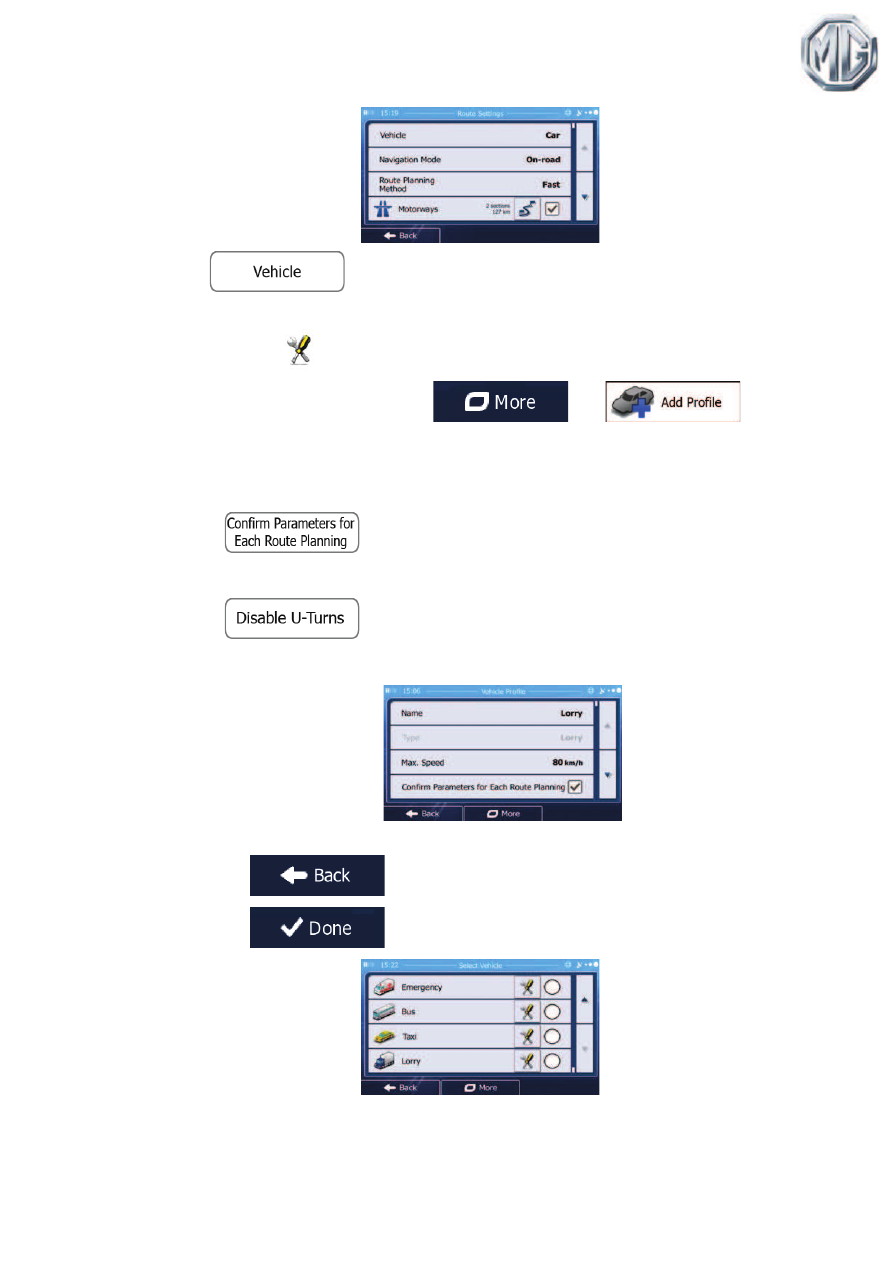
There is one Default Lorry profile at the end of the list. You can either: 

x   tap the 

 button at the Default Lorry profile or 

x  create a new profile by tapping 

 then 

and selecting Lorry as the vehicle type. 

6. 

The list of vehicle profile parameters appear. Scroll the list and tap any of the lines to 
change the parameters. The parameters are intuitive. In addition, you have the 
following options: 

x

: When enabled, the list of vehicle parameters always 

appears before route calculation. This helps you quickly adjust the parameters 
when some of them (the actual weight for instance) often change. 

x

: When selecting lorry as the vehicle type, U-turns are 

disabled from routes as much as possible. With this button you can even forbid 
turning back on divided roads. 

7. 

When finished with the vehicle parameters: 

x  tap 

 if you have modified an existing vehicle profile or 

x  tap 

if you have created a new profile. 

While  this  profile  is  selected,  the  parameters  of  your  vehicle  are  taken  into  account  when 
planning routes. Note that this leads to a safe route for your lorry only if map data contains the 
weight, height, etc. restrictions of the road network in your area. 

MG Motor UK Ltd 

83 

Tip!

 Speed limits for lorries may not be available for all roads. It is advised to enter 
the maximum allowed speed in your area for your vehicle instead of the 
maximum speed your lorry is capable of. 

Tip!

When you often use your vehicle with typical configurations of parameters (for 
example with or without a trailer that also affects the length, the height, the 
number of axles and the weight), it is better to create different vehicle profiles 
for the typical setups and change between the profiles instead of always 
modifying parameters. 

5.2 Setting up waiting time at waypoints 

In order to receive a better arrival time estimation and to be able to use time restrictions and 
statistical  traffic  information  for  future  legs  of  the  route,  you  can  enable  this  feature  and 
specify a waiting time for each stop on your route. 

If you enable the feature as described below, the application will ask you to enter the time you 
will spend at a stopover every time you enter a new destination. 

1. 

If you are on the Map screen, tap 

 to return to the Navigation 

menu. 

2. 

In the Navigation menu, tap 

, and then 

.

3. 

Tap 

.

4. 

Tap 

 to enable or disable this option. 

5. 

When finished, tap and hold 

 to return to the Map screen. 

MG Motor UK Ltd 

84 

5.3 Setting up driving time alerts 

In  order  to  obey  the  regulations  regarding  continuous  and  daily  driving,  you  can  set 
countdown timers to alert you when you need a break or a sleep. This feature can be set for 
one driver or two alternate drivers. 

1. 

If you are on the Map screen, tap 

 to return to the Navigation 

menu. 

2. 

In the Navigation menu, tap 

, and then 

.

3. 

Tap 

.

4. 

Tap 

 and set the driving timer defaults for the driver. 

5. 

(optional) Tap the switch to use the vehicle with two drivers. The timer defaults are the 
same but the timers will count down for each driver individually. 

6. 

When finished, tap and hold 

 to return to the Map screen. 

Whenever  the  vehicle  stops,  the  current  driver  receives  a  message  a  few  minutes  later 
whether this stop means a break. 

When a break is initiated, the continuous driving timer stops and it is reset to its default value, 
the daily driving timer also stops, and the break timer starts counting down (the break starts 

MG Motor UK Ltd 

85 

from the moment when the vehicle stopped). When the vehicle is in motion again, the break 
timer is reset, and both driving timers start counting down again. 

MG Motor UK Ltd 

86 

6 Reference Guide 

On  the  following  pages  you  will  find  the  description  of  the  different  concepts  and  menu 
screens of iGO primo. 

6.1 Concepts 

6.1.1 Smart Zoom 

Smart Zoom provides much more than just a usual automatic zoom feature: 

x

While following a route: when approaching a turn, it will zoom in and raise the view 
angle to let you easily recognise your manoeuvre at the next junction. If the next turn is 
at a distance, it will zoom out and lower the view angle to be flat so you can see the 
road in front of you. 

x

While driving without an active route: Smart Zoom will zoom in if you drive slowly 
and zoom out when you drive at high speed. 

6.1.2 Daytime and night colour themes 

iGO primo uses different colour themes during the day and during the night for both the map 
and the menu screens. 

x  Daytime colours are similar to paper road maps, and the menus are bright. 
x  The night colour themes use dark colours for large objects to keep the average 

brightness of the screen low. 

iGO  primo  offers  different  daytime  and  night  colour  profiles.  It  can  also  switch  automatically 
between the daytime and the night schemes based on the current time and GPS position  a 
few minutes before sunrise, when the sky has already turned bright, and a few minutes after 
sunset, before it becomes dark. 

6.1.3 Tunnel view 

When  entering  a  tunnel,  the  map  is  replaced  with  a  generic  tunnel  image  so  that  surface 
roads and buildings cannot distract you. 

The top-down overview of the tunnel helps you orientate yourself. The remaining distance in 
the tunnel is also displayed. 

After leaving the tunnel, the original map view returns. 

MG Motor UK Ltd 

87 

This feature can be turned off in Settings (page 110). 

6.1.4 Route calculation and recalculation 

iGO primo calculates the route based on your preferences: 

x  Route planning methods: 

x

: Gives a quick route if you can travel at or near the speed 

limit on all roads. Usually the best selection for fast and normal cars. 

x

: Gives a route that has the smallest total distance of all 

possible routes. It can be practical for slow vehicles. 

x

: Gives a quick but fuel efficient route based on the fuel 

consumption data given in Route settings (page 104). Travel cost and CO

2

emission calculations are estimations only. They cannot take elevations, curves 
and traffic conditions into account. 

x

: For vehicle types where Green routing is not available, this 

method combines the benefits of Fast and Short: iGO primo calculates as if it 
were calculating the Fast route, but it takes other roads as well to save fuel. 

x

: Results in a route with fewer turns and no difficult 

manoeuvres. With this option, you can make iGO primo to take, for example, the 
motorway instead of a series of smaller roads or streets. 

x  Vehicle types: 

When creating a new vehicle profile, select one of the below vehicle types. Besides 
the  below  mentioned  conditions,  dimension,  weight  and  freight  hazard  restrictions 
can also be taken into account when planning a route. 

x

:

x  Manoeuvre restrictions and directional constraints are taken into account 

when planning a route. 

x  Roads are used only if access for cars is allowed. 
x  Private roads and resident-only roads are used only if they are inevitable 

to reach the destination. 

x  Walkways are excluded from routes. 

x

:

x  Neither manoeuvre restrictions nor directional constraints are taken into 

account when planning a route. 

x  Roads are used only if access for pedestrians is allowed. 
x  Controlled-access roads are excluded from routes. 
x  A private road is used only if the destination is there. 

MG Motor UK Ltd 

88 

x  Speed limits are not used in route calculation and an average walking 

speed is used when calculating the estimated time of arrival. 

x

:

x  Manoeuvre restrictions and directional constraints (if they are applied to 

bicycles in the map data) are taken into account when planning a route. 

x  Roads are used only if access for bicycles or pedestrians is allowed. 
x  Controlled-access roads are excluded from routes. 
x  A private road is used only if the destination is there. 
x  Speed limits are not used in route calculation and an average cycling 

speed is used when calculating the estimated time of arrival. 

x

:

x  All manoeuvres are available in intersections. 
x  Directional constraints are taken into account the way that opposite 

direction is allowed with a low speed. 

x  A private road is used only if the destination is there. 
x  Walkways are excluded from routes. 

x

:

x  Manoeuvre restrictions and directional constraints are taken into account 

when planning a route. 

x  Roads are used only if access for buses is allowed. 
x  Private roads, resident-only roads and walkways are excluded from 

routes. 

x

:

x  Manoeuvre restrictions and directional constraints are taken into account 

when planning a route. 

x  Roads are used only if access for taxis is allowed. 
x  Private roads, resident-only roads and walkways are excluded from 

routes. 

x

:

x  Manoeuvre restrictions and directional constraints are taken into account 

when planning a route. 

x  Roads are used only if access for lorries is allowed. 
x  Private roads, resident-only roads and walkways are excluded from 

routes. 

x  U-turns are excluded from routes (turning back on a divided road is not 

considered as a U-turn). 

MG Motor UK Ltd 

89 

x  Road types used or avoided in route calculation: 

x

x

x

x

x

Whenever data exist, route calculation takes into account statistical traffic data for the given 
day of week and time of day (page 93). 

Real-time Traffic events are also taken into account and sometimes greatly modify the route. 

iGO primo automatically recalculates the route if you deviate from the proposed itinerary or if 
a newly received Traffic event concerns a part of the recommended route. 

For further information about Route settings, see page 104. 

6.1.5 Green routing 

Route  calculation  is  not  only  about  finding  the  quickest  or  shortest  route.  For  some  of  the 
vehicle  types,  you  can  also  check  the  fuel consumption  and CO

2

 emission  when  planning a 

route, and you can create cost effective routes with less effect on the environment. 

In  Route  settings,  you  can  edit  the  parameters  of  the  selected  vehicle.  Enter  the  fuel 
consumption values  and  the  price  of  the  fuel.  You  can  also  select  whether  you  want  to see 
the difference between your route and the green route even if the selected routing method is 
not Green. 

After the above parameters are set, select 

 as route planning method to 

get a fast but also fuel efficient route. Note that travel cost and CO

2

 emission calculations are 

estimations  only.  They  cannot  take  elevations,  turns,  curves  and  traffic  conditions  into 
account.  Also,  this  routing  is  not  meant  to  give  you  the  "greenest"  route  of  all.  It  is  still 
important  to  travel  quickly  so  the  result  is  a  fast  route  with  low  fuel  consumption  and  CO

2

emission. 

With  a  vehicle  type  where  green  routing  is  selectable,  whichever  route  planning  method  is 
selected, the Green details are also shown when you confirm the route: 

If the selected route planning method is not Green, and you have allowed the application to 
show  the  green  alternative,  the  price,  fuel  consumption  and  CO

2

  emission  differences 

between your selected route and the Green route are also shown on this screen: 

MG Motor UK Ltd 

90 

Tap the field with these details to switch the route to Green immediately. 

6.1.6 Road safety cameras and other proximity alert points 

There is a special proximity warning for road safety cameras (like speed or red light cameras) 
and other proximity alert points (like schools or railroad crossings). These alert points are not 
part  of  iGO  primo.  You  can  download  them  from  www.naviextras.com  or  you  can  upload 
points in a specific text file if needed. 

Dynamic alert points may also be available online at your location. 

You can also add your own alert points or edit the previously uploaded points. See page 76 
for details. 

The application can warn you when you approach road safety cameras like speed cameras or 
dangerous  areas  like  school  zones  or  railroad  crossings.  You  can  set  up  the  different  alert 
types individually in Sound and Warning settings (page 99).  

The following alert types are available: 

x  Audio warning: beeps can be played (natural voice) or the type of the alert can be 

announced (TTS) while you are approaching one of these points, and an extra alert 
can warn you if you exceed the given speed limit while approaching. 

x  Visual warning: the type of the alert point, its distance and the related speed limit 

appear on the Map screen while you are approaching one of these cameras. 

For  some  of  the  alert  points,  the  enforced  or  expected  speed  limit  is  available.  For  these 
points, the audio alert can be different if you are below or above the given speed limit. 

x  Only when speeding: The audio alert is only played when you exceed the given speed 

limit.

x  When approaching: The audio alert is always played when approaching one of these 

alert points. In order to draw your attention, the alert can is different when you exceed 
the speed limit. 

Note! 

The warning for road safety cameras is disabled when you are in a country 
where road safety camera warning is prohibited. However, you must ensure on 
your own liability that using this feature is legal in the country where you intend 
to use it. 

MG Motor UK Ltd 

91 

6.1.7 Speed limit warning 

Maps may contain information about the speed limits of the road segments. iGO primo is able 
to  warn  you  if  you  exceed  the  current  limit.  This  information  may  not  be  available  for  your 
region (ask your local dealer), or may not be fully correct for all roads in the map. 

The maximum speed set in the vehicle profile is also used for this warning. iGO primo alerts 
you if you exceed the preset value even if the legal speed limit is higher. 

Speed warning can be fine-tuned in Sound and Warning settings (page 99). 

You can set the relative speed above which the application initiates the warning. 

The following alert types are available:  

x  Audio warning: you receive a verbal warning when you exceed the speed limit with the 

given percentage. 

x  Visual warning: the current speed limit is shown on the map when you exceed it (for 

example:

). 

You can also choose to see the speed limit sign on the map all the time. 

6.1.8 Battery and GPS position quality indicators 

You can find useful information in the top corners of menu screens. 

The battery symbol in the top left corner, next to the current time shows information about the 
rechargeable battery of the device. 

Icon 

Description 

The battery is charging. The device runs on external power. 

The battery is not charging but it is full. 

The battery is not full but it still has enough capacity. 

You need to recharge the battery. 

MG Motor UK Ltd 

92 

In  the  top  right  corner,  the  GPS  reception  quality  icon  shows  the  current  accuracy  of  the 
position information. 

Icon 

Description 

iGO primo has no connection to the GPS receiver: GPS navigation 
is not possible. 

Devices  with  a  built-in  GPS  receiver  are  permanently  connected. 
On  such  devices,  the  icon  does  not  appear  in  normal 
circumstances. 

iGO  primo  is  connected  to  the  GPS  receiver,  but  the  signal  is  too 
weak and the receiver cannot determine the GPS position. 

GPS navigation is not possible. 

Only a few satellites are received. Position information is available, 
but elevation (altitude) cannot be calculated. 

GPS  navigation  is  possible,  but  the  position  error  may  be 
significant. 

Altitude information is available, the position is a 3D position. 

GPS navigation is possible. 

6.1.9 Traffic information in route planning 

The recommended route is not always the same between two points. Offline statistical traffic 
information  (historical  speed  information  or  traffic patterns) can be  taken  into account  in  the 
route calculation based on the time of day and the day of week whenever suitable data exists. 
In addition, real-time traffic information can help you avoid current traffic events like temporary 
road  closures  or  a  traffic  jam  caused  by  an  accident.  Both  functions  are  subject  to  data 
availability.

You can display the historical traffic information on the map if you browse the map and select 
this option from the More menu. A 2D map is displayed with road segments coloured by the 
density of the traffic in the given period. The current information is shown when you open the 
screen. Modify the day of week and the time of day to see the desired period. 

You can display the live traffic information on the map if you browse the map and select this 
option  from  the  More  menu.  A  2D  map  is  displayed  with  road  segments  coloured  by  the 

severity of traffic events. Tap the event type icon at the road segment and then tap the 
button to get information about the traffic event.  

MG Motor UK Ltd 

93 

6.1.9.1 Historical traffic 

If  statistical  traffic  information  is  stored  with  the  map  data,  iGO  primo  can  take  them  into 
account when planning a route. In normal cases, these statistics help you avoid usual traffic 
jams on the given day of week in the given hour but in some cases like on public holidays that 
fall  on  normal  weekdays,  they  can  be  misleading.  You  can  disable  this  feature  in  Traffic 
settings (page 103). 

You can display statistical traffic information on the map if you browse the map and select this 
option from the More menu. 

6.1.9.2 Real-time traffic information (TMC) 

TMC (Traffic Message Channel) can provide you with the real-time status of the traffic. Route 
calculation can avoid road blocks or unexpected traffic jams caused by an accident. 

Note!  This feature is available only if your hardware supports TMC. 

TMC is a specific application of the FM Radio Data System (RDS) used for broadcasting real-
time traffic and weather information. 

Using traffic information is enabled by default in iGO primo. 

Note! 

TMC is not a global service. It may not be available in your country or region. 
Ask your local dealer for coverage details. 

[DEVICE]  may  contain  the  TMC  receiver  that  is  needed  to  receive  Traffic  events.  Ask  your 
local dealer. 

If public Traffic data is broadcast at your location, iGO primo automatically takes into account 
the traffic events received. You do not need to set anything in the program. The receiver will 
automatically  search  the  FM  radio  stations  for  TMC  data,  and  the  decoded  information  will 
immediately be used in route planning. When iGO primo receives traffic information that may 
affect your route, the program will warn you that it is recalculating the route, and navigation 
will  continue  with  a  new  route  that  is  optimal  considering  the  most  up-to-date  traffic 
conditions.

To  fine-tune  this  recalculation,  you  can  set  the  minimum  delay  that  can  trigger  a  route 
recalculation, or you can instruct iGO primo to have you confirm the new recommended route 
before it takes effect. You can do these in Traffic settings (page 103). 

A special icon (

) is displayed on the Map screen to show you whether traffic events are 

received. The icon shows the status of the traffic receiver when there are no traffic events on 
your route, otherwise it shows the type of the next traffic event on your route. 

Road segments affected by traffic events are displayed with an alternate colour on the map, 
and small symbols above the road show the nature of the event: 

MG Motor UK Ltd 

94 

1. 

Tap 

 to open the Traffic Summary screen: 

2. 

Tap 

 to open the list of of event categories. 

3. 

Tap the traffic category you are interested in, or tap 

 to see the list 

of all events: 

4. 

Now tap any of the list items to see its details, and to display the affected road 
segment in its full length on the map: 

Note! 

If there are traffic events on the recommended route that the application has not 

bypassed, the 

 icon will open the list of significant traffic events to let you 

quickly check them. 

MG Motor UK Ltd 

95 

6.1.9.3 Online traffic information 

Unlike statistical traffic information, online traffic can provide you with the real-time status of 
the traffic. Route calculation can avoid road blocks or unexpected traffic jams caused by an 
accident. 

Note!  This feature needs an active internet connection. 

The application automatically takes into account the traffic events received. You do not need 
to  set  anything  in  the  program.  When  iGO  primo  receives  traffic  information  that  may  affect 
your  route,  the  program  will  warn  you  that  it  is  recalculating  the  route,  and  navigation  will 
continue with a new route that is optimal considering the most up-to-date traffic conditions. 

To  fine-tune  this  recalculation,  you  can  set  the  minimum  delay  that  can  trigger  a  route 
recalculation, or you can instruct iGO primo to have you confirm the new recommended route 
before it takes effect. You can do these in Traffic settings (page 103). 

A special icon (

) is displayed on the Map screen to show you whether traffic events are 

received. The icon shows the status of the traffic reception when there are no traffic events on 
your route, otherwise it shows the type of the next traffic event on your route. 

Road segments affected by traffic events are displayed with an alternate colour on the map, 
and small symbols above the road show the nature of the event: 

1. 

Tap 

 to open the Traffic Summary screen: 

2. 

Tap 

 to open the list of event categories. 

3. 

Tap the traffic category you are interested in, or tap 

 to see the list 

of all events: 

MG Motor UK Ltd 

96 

4. 

Now tap any of the list items to see its details, and to display the affected road 
segment in its full length on the map: 

Note! 

If there are traffic events on the recommended route that the application has not 

bypassed, the 

 icon will open the list of significant traffic events to let you 

quickly check them. 

6.2 'More' menu 

The  'More'  menu  provides  you  with  various  options  and  additional  applications.  Tap  the 

following buttons:  

,

.

Button 

Description 

Visit www.naviextras.com to get additional content, such as new maps or 
3D landmarks and useful applications. 

Access  the  music  player  application  to  play  backround  music  during 
navigation.  Create  a  playlist  from  the  music  files  stored  on  your  device 
and entertain yourself during your journey. Audio warnings and guidance 
messages  still  guide  you  on  your  route  as  the  application  can  fade  the 
music while these announcements are played. 

Access  the  Picture  Viewer  application.  View  the  pictures  stored  on  your 
device. If coordinates are stored in your photos, you can start navigating 
to the place where the selected photo was taken. 

Access travel applications: the unit converter helps you convert between 
various different international units for temperature, speed, area or 
pressure, etc. 

Access travel applications: the clothing size converter helps you convert 
between various different international size units for men's or women's 
cloth types and shoes. 

MG Motor UK Ltd 

97 

Tap this button if you have a redeemable code that activates online 
services to your connected device. Enter the code when your device is 
connected to the Internet and the application will activate the services 
online. 

The scientific calculator helps you in all your calculation needs. Tap the 
Mode button for additional functions and use the memory to save your 
results. 

The Fuel consumption monitor helps you keep track of the consumption 
of your car even if you do not use navigation for all your journeys. Set the 
initial odometer value and then record the distance taken and fuel filled in 
whenever you fill your car. You can also set reminders for regular car 
maintenance. 

Tap this button to see the sunlit and dark areas of the world. Your current 
location and route points are marked on the map. Tap the Details button 
to see the exact sunrise and sunset times for all your route points (your 
current location, all waypoints and the final destination). 

If you save your trip logs when you arrive at some of your destinations or 
let the application automatically save the trip logs for you, those logs are 
all listed here. Tap one of the trips to see the trip statistics, speed and 
altitude profile. If track log has also been saved, you can display it on the 
map with the selected colour. Track logs can be exported to GPX files for 
later use. 

Select a country from the list and see useful driving information about the 
selected  country.  Information  may  include  speed  limits  on  different  road 
types,  the  maximum  blood  alcohol  level  and  any  compulsory  equipment 
you need to show when stopped by the police. 

Run the Demo and watch sample route simulations to see how navigation 
works. 

The  About  section  provides  you  with  product  information.  Read  the 
Software and Database End User License Agreement, or check the map 
and  other  contents  of  the  application.  You  can  also  access  program 
usage statistics. 

6.3 Settings menu 

You  can  configure  the  program  settings,  and  modify  the  behaviour  of  iGO  primo.  Tap  the 

following buttons:  

,

.

The Settings menu has several options. Tap 

 or scroll with your finger to see the full list. 


Content      ..     4      5      6      7     ..